
Ad Blocker Detected
Our website is made possible by displaying online advertisements to our visitors. Please consider supporting us by disabling your ad blocker.
From a small village of the Bana people next to the Dak Bla river, people of the Xo Dang, Bana, Gia Rai, Gie – Trieng, Brau, Ro Mam,… ethnic groups came to settle, live, and become mandarins. The political, economic, cultural and social importance of the vast and majestic Central Highlands… the land of Kon Tum has gone through many changes and ups and downs with many changes of name and location. administrative world. Going back in time, learning about the historical periods that Kon Tum has gone through, making us appreciate even more the will, energy, courage and internal strength of the land and people here in their journey of advancement. same country.
Kon Tum is a province with a young population. By 2009, the province’s population was 432,865 people (Statistical Yearbook 2009). Kon Tum has 25 ethnic groups living together, of which ethnic minorities account for over 53%, there are 6 ethnic minorities living for a long time including including: Xo Dang, Bana, Gie-Trieng, Gia Rai, Brau and Ro Mam,… After the country’s unification (1975), a number of ethnic minorities in other provinces came to live and become members of the country. Ethnic groups in the province are increasingly diverse.
According to legend of the Bana people, Kon Tum was originally just a village of the Bana people. At that time, the Bana ethnic group (now Kon Tum city) had a local village near the Dakbla river called Kon Trang – OR. At that time, Kon Trang – OR village was very prosperous with a large population. At that time, villages were always fighting with each other to confiscate wealth and capture people as slaves. The two sons of Ja Xi – one of the leaders of Kon Trang – OR village named Jo Rong and Uong, did not like the war and built their own house near the lake, next to the Dakbla river. This land is very favorable for a settled way of life, so gradually more people came to live, growing more and more every day, establishing a new village called Kon Tum. From then on, Kon Tum became the official name for a newly established village of the Bana people, next to the Dakbla stream, where there are many low-lying lakes. In Kinh language, Kon Tum means Lake Village (Kon is village, Tum is lake, pond, water tank,…).
Due to its special location, Kon Tum is a flat land, surrounded by the Dakbla River and deposited with fertile alluvium. Experiencing the upheavals and ups and downs of history, this land has undergone many changes, with people from all ethnic groups gathering here in increasing numbers. When Kinh people came to the Central Highlands, they also chose Kon Tum as a place to settle. Since then, Kon Tum has become a residential area of many ethnic groups.
Promoting the advantages of natural conditions with the diligence of people, the land of Kon Tum is increasingly prosperous, not just one village but many villages, covering a large land area. This land when the town was established was also officially called Kon Tum. When the provincial administrative unit was established, Kon Tum was still officially used as the name of the province. This is the earliest administrative geographical region formed in the Central Highlands.
Kon Tum territory through historical periods
In the past, Kon Tum was still very desolate, with few people and a large land. Indigenous ethnic groups include Xo Dang, Bana, Gia Rai, Gie – Trieng, Brau, Ro Mam. Each ethnic group is associated with a different region of residence. A special feature of the traditional social institutions of ethnic groups in Kon Tum province is that the only social organization is the village. The village is considered a comprehensive and specific administrative unit, governing all activities in social life. Each village has its own independence, led by a village owner who is the most prestigious person in the village.
During the Tay Son uprising (1771 – 1786), the three brothers Nguyen Nhac, Nguyen Hue, and Nguyen Lu built a relationship of solidarity with the peoples of this region.
In 1840, under the reign of King Thieu Tri, the Hue court established Bok Seam – a Bana man – to rule over the Central Highlands tribes, and at the same time allowed Kinh people and people of other ethnic groups to freely trade and exchange relations. change. From here, Kinh merchants began to come to the Central Highlands to buy, sell and exchange goods.
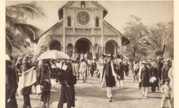
During this time, the French also found their way to Kon Tum to preach. During the period 1841 – 1850, the French colonialists established the first Catholic establishment in Kon Tum.
In 1867, the French colonialists began to invade Kon Tum – Central Highlands. Using sinister tricks to divide the ethnic groups in the region, the French colonialists annexed Kon Tum and the Central Highlands.
In 1892, the French colonialists placed the first administrative agency building in Kon Tum, managed by a French priest named Vialleton, also known as Father Truyen.
On July 4, 1904, the French colonialists established Plei Ku Der province, including two administrative offices: one in Kon Tum (formerly in Binh Dinh province) and one in Cheo Reo (previously in Binh Dinh province). Phu Yen).
On April 25, 1907, the French colonialists officially abolished Plei Ku Der province. All land of Plei Ku Der province, including two administrative agency buildings Kon Tum and Cheo Reo, were merged back into Binh Dinh and Phu Yen provinces as before.
On February 9, 1913, the French colonialists officially established Kon Tum province, including Kon Tum administrative agency separated from Binh Dinh, Cheo Reo administrative agency separated from Phu Yen, and Buon Ma administrative agency. Thuot (Buon Ma Thuot was previously a separate province, but in 1913 it was reduced from a province to an administrative agency, merged into Kon Tum province).
In 1917, the French colonialists established the An Khe administrative agency, including Tan An district and ethnic minority areas under the rule of the Kon Tum province envoy.
On July 2, 1923, Buon Ma Thuot agency was separated from Kon Tum province to establish Dak Lak province.
On December 3, 1929, Kon Tum city was established (actually at that time it was just a town, including Tan Huong district and a number of neighboring ethnic minority villages).
On May 25, 1932, Pleiku agency was separated from Kon Tum province, establishing Pleiku province (now part of Gia Lai province). On August 9, 1943, An Khe administrative agency was separated from Kon Tum province and merged into Pleiku province. At that time, Kon Tum province only had Tan Huong district and all ethnic minority land left.
Tong Tan Huong is the predecessor name of the current Kon Tum city. Cang Tan Huong is the convergence of Kinh villages to settle down in Kon Tum. In order, the villages of Tan Huong canton were established by time and name as follows: Tan Huong (1874); Phuong Nghia (1882); Phuong Quy (in 1887); Phuong Hoa (1892); Trung Luong (1914); Phung Son (1924); Ngo Thanh (1925); Ngo Trang (1925); Phuoc Can (1927); Luong Khe (1927).
On February 3, 1929, according to the decree of the Central Ambassador, Tan Huong canton was established as Kon Tum town, from then on Kon Tum town became the political – economic – social center of Kon Tum province. Over time, the land here is constantly expanding and developing. In addition to the villages founded by the Kinh people, later there were many more villages of ethnic minorities in the suburbs such as Kon Rbang, KonM’nai, ChuHreng villages, also within the administrative management scope of Kon Tum town.
In August 1945, along with the whole country, on August 25, 1945, the people of Kon Tum rose up to seize power. The revolutionary government reorganized Kon Tum province into four administrative units including Dak Glei, Dak To, Konplong districts and Kon Tum city. The provisional revolutionary government of Kon Tum province was established with headquarters in Kon Tum city to lead the people to begin building a new life.
On June 26, 1946, the French colonialists attacked and recaptured Kon Tum, reestablishing the governing apparatus of this region. Compared to before the August Revolution of 1945, the French ruling apparatus and policy from province to village have not changed much. The head of the provincial administrative apparatus is a French envoy, below there are districts usually held by a French station chief and then villages. The French colonialists gathered local henchmen, especially to seduce, bribe, and manipulate village owners to hold the power apparatus at the grassroots level.
On the revolutionary side, after the French colonialists recaptured Kon Tum, the provisional revolutionary government disintegrated, the Party organization was scattered and lost. During this time, Kon Tum province was under the administrative management and direction of the Central Party Committee and the National Minority Mobilization Committee of the South Central region.
In January 1947, Division 15 was established, with the core being Kon Tum province and the western districts of Quang Nam and Quang Ngai provinces. In fact, Kon Tum’s administrative organization remains the same, but is managed and controlled by Division 15 regarding military activities. In August 1947, Zone 15 of the Central Highlands was established, Kon Tum province was one of the administrative units under Zone 15. In March 1950, according to the policy of Inter-Zone Party Committee V, Kon Tum province and Gia Lai province was merged into Gia – Kon province. The Gia – Kon staff decided to establish 7 zones (districts). Kon Tum province is organized into 3 zones: zone 1 (Dak Glei); Area 2 (Dak To); Area 3 (Konplong).
In October 1951, according to the decision of Inter-Regional Party Committee V, Kon Tum province and the western districts of Quang Ngai merged into the Western Front.
In February 1954, Kon Tum was the first and only province in the Central Highlands to be completely liberated. Some time later, the Western Front was also dissolved. In the spirit of the Geneva Agreement signed on July 20, 1954, Kon Tum province entered a new historical period.
On the enemy’s side, after the Geneva Agreement was signed, the US – puppet took over Kon Tum. In 1958, they divided the administrative apparatus of Kon Tum province into Kon Tum administrative court – the provincial administrative apparatus, below which included the districts of Kon Tum, Dak To, Konplong and Dak Sut.
In 1958, the puppet government established Tomorong district. In 1959, the puppet government established Chuong Nghia district. In 1960, Konplong district was abolished. Thus, in fact, Tomorong and Chuong Nghia districts occupy nearly the entire area of the previous Konplong district. The remaining part of Konplong district that is not within the scope of these two new districts was merged into Kon Tum district.
In 1961, Chuong Nghia district included land east of Dak Nghe river, bordering Ba To (Quang Ngai) and was cut into Quang Ngai province. Kon Tum province has 4 remaining district-level administrative units: Kon Tum, Dak To, Dak Sut, Toumorong.
After 1965, the administrative hierarchy of the Saigon puppet government in Kon Tum changed. For densely populated town and town areas, they remain at the district level; In remote, less populated places, they reduce districts to administrative envoys.
In 1970, the enemy’s administrative apparatus, in addition to the administrative court and companies and departments in the province, had the following levels below: Kon Tum district, Dak To district, Dak Sut administrative envoy, Mang Buk administrative envoy, Chuong Nghia administrative envoy (Chuong Nghia district moved to Quang Ngai for a while then was merged back into Kon Tum province).
In 1972, the puppet government renamed the Dak Pet district into Dak Sut district to expand its administrative functions.
After the spring – summer campaign of 1972, the revolutionary army liberated Dak To – Tan Canh and the majority of rural areas, the enemy’s control area was significantly narrowed; The enemy’s Dak To district capital had to be exiled to Sao Mai pass (southeast of Kon Tum city); Dak Pet, Mang Den, Mang Buk sub-regions are isolated in our liberated areas. The enemy remained largely confined to the Kon Tum city area.
In 1974, our army attacked and completely destroyed the Dak Pet, Mang Den, and Mang Buk sub-regions. Taking advantage of the great victory in Buon Ma Thuot, on March 17, 1975, the army and people in the province rose up to attack the enemy’s headquarters in the inner city, liberating the city and the entire province of Kon Tum.
On our side, in early 1955, the whole province was divided into 6 rural areas (equivalent to districts) and one city.
Area 1: initially the east and north of Kon Tum city, from the bank of Po Ko river (west) to the bank of Dak Nghe river (east).
Area 2: includes the entire Konplong district today.
Area 3: includes some areas of Dak Glei district and some areas of Dak To (now in Dak Ha district) bordering area 6 and bordering Konplong district today.
Zone 4: western region of Dak Glei district from Quang Nam to Dak Nay Pui, bordering Laos to the west.
Zone 5: was formed and dissolved before the Geneva Agreement, so it no longer exists. Part of zone 5 merges into zone 4, the remaining part merges into zone 6.
Zone 6: from Vomona, the east borders Mang Buk to the Kayong region bordering Laos, the north borders Dak Ha region, the south borders Konplong.
Area 7: belongs to Sa Thay district today.
At the end of 1956 and early 1957, the areas were rearranged and converted into districts: part of area 3 bordering area 6 was cut into area 8; cutting a southern part of zone 2 into zone 9; Dissolve zone 6. Form districts: zone 1 and part of zone 6 merged to form district H16; Zone 2 and Zone 9 merged to form district H29; Area 3 changed to district H30; Area 8 and part of Area 6 merged into district H80; Area 4, district H40; Area 7 and part of Area 6 merged to form district H67.
During the resistance war against American imperialism, districts in Kon Tum province were all called by code names such as: H16, H29, H30, H40, H67, H80. Kon Tum city at that time had the code name H5. KonHring region (now part of Dak Ha district) has the code name H9.
Each codename has a specific name: H16 (Konpraih); H29 (Konplong); H80 (Dak To); H5 (Kon Tum city); H30 (east of Dak Glei); H40 (west of Dak Glei); H67 (Sa Thay); H9 (Kon Hring).
After Kon Tum province was liberated (March 17, 1975), the whole province had Kon Tum city and 6 districts: H30, H40, H16, H29, H80, H67.
In October 1975, Kon Tum province merged with Gia Lai province to form Gia Lai – Kon Tum province, in the province there are districts: Konplong district (H16 + H29), Dak Glei district (H30 + H40), Kon city Tum (H5 + H9), Dak To district (H80). In 1979, Sa Thay district was established on the basis of the land of old H67.
In October 1991, Kon Tum province was re-established on the basis of dividing Gia Lai – Kon Tum province. Accordingly, a number of new districts were established such as Ngoc Hoi (1992); Dak Ha (in 1994), Kon Ray district (in 2002), Tu Mo Rong district (in 2005).
By 2005, Kon Tum province had 01 city and 8 districts. Among them, Kon Tum city is the political, economic, cultural and social center of the province.

